Showing posts with label kathmandu. Show all posts

Monday, 28 May 2012

Kathmandu Royal National Park Race Debrief

Yesterday my teammate Glenn and I completed the Kathmandu Adventure Race in the Royal National Park (RNP) in Sydney.

It was a great race, very well organised with a great weather. 

Nothing like my very first adventure race in the Royal National Park three years ago where it was pouring rain and so cold! Check the pictures below:


Covered in mud but smiling  So happy to cross the finish line!
This time the sun was out and the temperature was perfect for the race.

The organisers actually changed the bike drop location, and maybe a great omen, the picture featured in their email had Glenn and I rushing from the starting line!

The two guys with the white caps and the sunnies in the middle, that's us!

Copyright Maximum Adventure
After registering and grabbing our registration bag and bibs, we discovered that we were going to do the grey course. This involved the following legs:
  • Run
  • Bike
  • Run
  • Canoe
  • Run
  • Kayak
After reviewing the instructions and writing critical information on the map (I am planning to do a movie on this later on), we cut away most of the useless bits to keep the map as small as possible and then contacted it. While I bought a waterproof map holder, I don't find it very useful when racing.

Glenn, having built an awesome map holder for his bike, we decided that for the first leg, he would not only do the navigation but also dip the timing chip at the bike checkpoints. Being faster on the bike, he would make up the time lost stopping and dipping the timing chip while I would continue riding with my old mountain bike. This worked well, Glenn did an amazing job and we did a very strong bike leg. I was actually very happy and surprised with my performance on the old bike! As you will have read/seen in the previous post (Crushed Bike, Last Patrol & Adventure Racing), I crushed my beloved competition mountain bike and so was back to riding the old mountain bike I used three years ago in the RNP race!

For the people new to adventure racing, being able to adapt and balance the strengths and weaknesses between you and your team mate(s) prior and during a race is really important.

After that, we ran a short leg to the start and then to the boat shed. Thankfully we did not have to row a boat as done in the last few years (gosh these boats are horrible and you feel like in a huge pinball or bumper car going from one river bank to another). 

Got really annoyed with Glenn a few times as paddling he was watering half my body and shoe with icy cold water. I felt like hitting him with my paddle on the head but decided not to as this would not have increased our chances of winning.

Not sure if Glenn has been watching too many "Starsky and Hutch" on TV but for the last checkpoint with the canoe, he decided to jump off the canoe, run to the checkpoint under the bridge and jump back onto the canoe. It was not that smooth and a team overtook us in the process but at least we did not capsize!

Anyways, back on the firm ground, we ran up the infamous "Honeymoon Track", a seriously steep track with lots of steps to start the main run leg. I did the navigation and sadly did a small navigation mistake that costs us 10 minutes and then lost some more time looking for a very tricky checkpoint (#18) towards the end.

By then, we had been racing for 2h30mins, my quads were starting to cramp and Glenn's knee was starting to give him grief.

After a steep run down Honeymoon track (so much easier than going up) encouraging people on the way up with "Good job!" and "Keep going! Nearly there!" generating several smiles on the go, we got back to the final transition at the start/finish.

We jumped into a kayak, paddled frenetically to the last two checkpoints and crossed the finish line with a massive smile on our faces in 3 hours and 18 minutes.

We finished 9th overall out of 188 teams and 6th for the male category. Not bad!

For more details, check the results HERE on the Maximum Adventure website.

The best is always at the end, eating a delicious and freshly grilled burger sitting down in the sun going through the race with many other competitors and sharing each other's pains and funny moments.

This was definitely a great workout and without my two mistakes, we would have been sub three hours (a time we are normally more used to) and closer to the podium. Next time!

While I do enjoy a few days resting, my next race is coming up next Sunday with the MS Fun Run. The MS Fun Run is a great initiative to raise funds and awareness around Multiple Sclerosis (MS). It is a great run, in the words of the organisers: "A challenging route through picturesque harbour-side streets from Milsons Point to Balls Head Reserve and return. Finish with a sprint down the famous Luna Park boardwalk".

I have created a profile and I would like to invite you to sponsor me to raise funds for people affected by Multiple Sclerosis (MS) by clicking on the image/link below:


Sunday, 20 May 2012

Mont Blanc Training, MS Fun Run & Kathmandu RNP

This week has been really focused on cardio with lots of running.

A serious and good training leading up to climbing Mont Blanc, could either be:
  • running three times a week for one hour or
  • hiking every weekend and climbing an elevation of 1800 meters
 for the three months prior to the climb.

Living in Sydney sadly, we do not have many of these elevations around so my training is mainly focusing on the running! Though I plan on going back to Mt Kosciuszko prior to going to France.

I really love running back home from work. I found it the best way to finish the day and let off some steam. My running itinerary takes me from the city through the botanic gardens, the Opera house, circular quay, across the Harbour bridge and then uphill  to the North Shore.

With daylight savings, I am now running after dark (very handy & safer to wear reflective materials and headlights) and Sydney by night is just splendid. Feel really grateful to be able to live, work and run in such a beautiful city and environment! And I also love the fact that door to door I am actually faster than the bus at peak hour and not polluting a bit!  

I also ran this morning around Luna Park and Balls Head. I am currently preparing for the MS fun run on June 3rd (and also for the Kathmandu Adventure Race at the Royal National Park next weekend). The MS Fun Run is a great initiative to raise funds and awareness around Multiple Sclerosis (MS). It is a great run, in the words of the organisers: "A challenging route through picturesque harbour-side streets from Milsons Point to Balls Head Reserve and return. Finish with a sprint down the famous Luna Park boardwalk".

I did the run two years ago and finished second of my category in 31mins 52s. While I did not train seriously for this race leading up to it this year, I went for a trial run this morning and did the itinerary in just under 36mins. So not quite there! A few minutes to shave off!

Will be running twice next week (not including the Kathmandu Adventure Race) and plan on doing the MS Fun Run itinerary a few times before the race. It is a tough race with lots of up and downs to be done at a fast pace but again, a beautiful scenery which makes it really worthwhile! Whether you walk it or run it, it is a great way to exercise, make a difference for people with MS and enjoy a beautiful scenery. I highly recommend doing it!


Tuesday, 15 May 2012

Kosciuszko - Part 6: Prepare - Gear


Your gear is the most important and the trickiest item to prepare for this hike.

Due to the unstable and sometime rapidly changing weather (ie cold, rain, fog, wind, etc.), you need to make sure you have the appropriate gear.  Rather than long explanations, just check the two pictures below:


Start of the track on Saturday     End of the walk on Sunday

It started super sunny and finished cold as, raining and foggy. Better be prepared!

To make it easier for you to prepare, I took a picture of the gear I packed for the weekend:


You can buy most of the items in your local camping/outdoor store. Most of my gear is from Kathmandu and was perfect for this adventure.

There are 4 categories of gear:
As you can see, there is quite a lot of gear to cover. So please use the hyperlinks above to go directly to a specific group or section!
Clothes (white group)
  1. Cargo / Zip-off Pants
  2. Fleece 
  3. Waterproof / Gore Tex jacket (compulsory)
  4. Breathable / Sports top 
  5. Socks /Undies
  6. (Board)short 
  7. Long sleeve thermal top
  8. Skins / compression gear (optional)
     Not shown – beanie (compulsory)
     Not shown – hiking boots or trail running shoes

You need to take with you a Gore-Tex/waterproof jacket in case it rains or gets cold. The last thing you want is to be caught in the middle of the walk and suffer hypothermia.

Make sure you pack warm clothes (thermal, beanie) for evenings and also for cold/rainy/windy weather and light clothes for sunny weather. Zip-off pants might be a good idea to be used either as pants or shorts.

At night time, the temperature drops close to zero; make sure you wear a beanie to stay warm.

Also make sure your shoes are broken down or you have used them for long walks. I have used trail running shoes which was fine for the entire trail and great to run up to Mt Townsend!

Compression gear might be a good idea to accelerate blood flow, reduce build-up of lactic acid, stay warm and prevent chaffing. To be worn during or after the walk to recover.

Pack (orange group)
  1. Big backpack (65L) 
  2. "Camelback" bladder (2L)
  3. Inflatable mattress
  4. Tent
  5. Sleeping bag
  6. Day pack
A good backpack is paramount. The light daypack will be great after setting up the camp to go to Mt Townsend with only a few things with you.

The inflatable mattress will ensure you have a good sleep (especially after a long day trekking!) and ensure the cold is not transmitted through to your body/back. You do not need a full body length one, as long as your back is not against cold hard ground, you are sweet.

An easy to mount and light tent will be best to pitch at the end of the day.

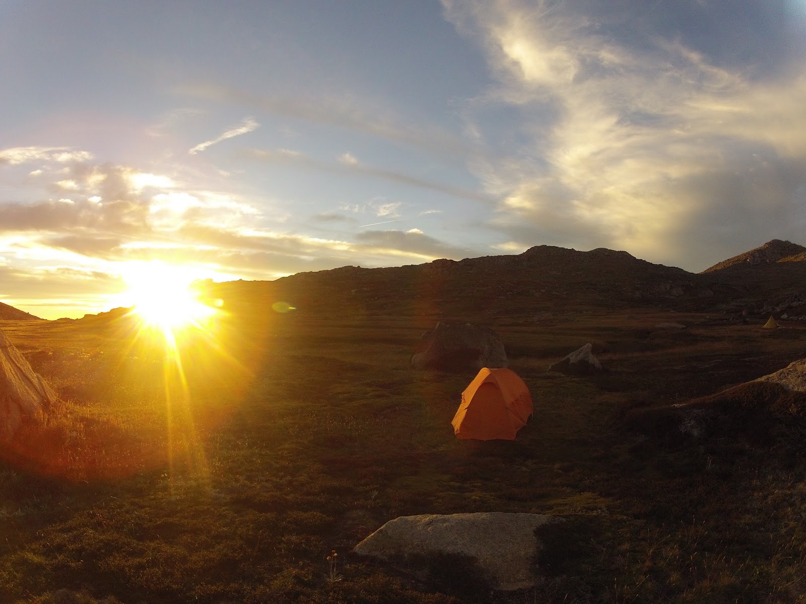
Camping in the valley
 
Personal (green group)
  1. Topographic Map – Perisher Valley 85252S ~$9.95 (compulsory) & Wildwalks Notes
  2. Waterproof map case (optional) 
  3. Compass (compulsory) 
  4. First aid kit (compulsory) (here in waterproof bag) 
  5. Purification tablets (preferable) 
  6. Emergency matches 
  7. Sunscreen (compulsory) 
  8. Sunnies (compulsory)
  9. Hat / cap (compulsory) 
  10. Insect repellent (preferable) 
  11. Cleaning wipes (preferable) 
  12. Toiletries bag with what you need (contact liquid, etc.) 
  13. Bepanthem (to prevent chaffing) 
  14. Toilet paper 
  15. Trowel 
  16. Head torch 
  17. Camera / GoPro!
Not shown – Telephone
Not shown – Towel

Ok lots of critical items here! 

First aid kit, map and compass are compulsory. Protection against the sun as well.

To find out where you can buy topographical maps close to where you live, click here. I went to Map Worldin Sydney CBD to purchase the map, and was really impressed with their customer service. Very helpful if you plan on going off-track. Otherwise you can buy a mini map for ~$5 from the visitors centre in Jindabyne. I also recommend reading/printing/taking the notes from Wildwalks on this trek, they are very useful.

There is plenty of water around but it’s preferable to boil/purify it before drinking. Make sure you have means to do either. Also you need to be able to create a fire in case of emergency, so equip yourself with either a small/light camping stove or emergency matches.

Bring a telephone. While in many parts of the national park you do not have coverage and you CANNOT rely on your mobile as an emergency communication device, I found that on higher grounds with Telstra I had several bars and could place a call. No idea what the coverage is with other carriers. If you go alone, it might be worth considering renting an emergency beacon from the visitors centre in Jindabyne.

Cleaning wipes are the bomb for your personal hygiene. They are cheap, do not take much space and are super refreshing. Again, take your rubbish with you!

Food (red group)
  1. Metal Pot
  2. Spork (a combined plastic spoon, fork and knife)
  3. Leatherman / Swiss Army knife
  4. Stove (preferably with piezo so you do not need matches to lit it)
  5. Gas canister
  6. Dehydrated food (Back country cuisine)
  7. Snack bars
  8. Lollies / dried fruits / nuts
  9. Tins (soup / bakes beans / tuna)
  10. Cup
  11. Tea bags / Instant Coffee
  12. Rubbish bags (compulsory) 
Not shown – Water
Based on my experience with this weekend trek, just get snacks, a medium pot and dehydrated food. The metallic pot will be good to boil enough water for your meal and to fill a water bottle.
Tins are cheap but bulky and heavy to carry, and after eating them, they are messy/sharp and still take a lot of space. Sandwiches might be a cheap option but it might be difficult to find time making them, keeping them from being squashed in the pack and staying fresh with the heat!

Dehydrated food is a bit more expensive, but just boil water, put it in the bag, wait a few minutes and you can then directly eat it from the bag (so no dishwashing!). I was happily surprised to see that it’s pretty good (though after a long day walking any warm food would be considered good ;). It is light to carry before and after eating it and it does not take much space. Your back will thank you.

As usual, take your rubbish with you!

Let me know if you found the above pictures and tips helpful and in the next post, we will see pictures and videos of the actual walk.

Wednesday, 4 April 2012

Kosciuszko - Part 3: Decide when to go / checking the weather

Welcome back!

So you have trained, maybe done a few adventure races with our good friends at Maximum Adventure and you are ready to climb Mt Kosciuszko!

The best season to walk to the top of these two mountains is between April and November. 

The weather is more stable and warmer at this time, but severe storms, strong winds and even snow are possible any time of year. You need to be ready for cold, wet and windy conditions at all times (and pack accordingly!)

Summer temperatures range from -1° to 30°C while winter goes from -12° to 10°.

Just check the pictures below to get an idea of how the weather can change within 24hrs:


Start of the track on Saturday     End of the walk on Sunday

We started the walk with really sunny and warm weather and wore shorts and tee shirts. The very next morning, it was raining, windy, colder and foggy. 

A gore-tex/waterproof jacket (my loved one - above - is a Kathmandu Armstrong that I use for all my outdoor activities (running, adventure racing, etc.) to stay dry and a fleece to stay warm are must haves! I will go through the gear you need to pack with you in detail in a next post. These pictures are more to show you practically what to wear and what to expect!

The weather will clearly be the main deciding factor in choosing “the” weekend to go to the Kosciuszko National Park.

I would recommend checking it regularly using the great Bureau Of Meteorology (BOM) website and the forecast for the Perisher Valley area:

http://www.bom.gov.au/nsw/forecasts/perisher.shtml 

As you need to drive the Friday afternoon, I would suggest making the call to go there on the Thursday afternoon after the latest update from the BOM (generally the BOM issue a forecast update around 4/5pm). 

Being Thursday, you can then do late night shopping to get last minute items or food you need for the trip... and pack! 

In the next post, we will talk about how to get there!

Tuesday, 3 April 2012

Kosciuszko - Part 2: Prepare - Fitness

G'day!

So you want to go to the top of Mt Kosciuszko and Mt Townsend but now you are wondering how fit you need to be?

Well, while going to the top of Mt Kosciuszko is nowhere close to the effort required to climb Mt Blanc, it still requires a decent level of fitness and endurance.

The Main Range Track is a 28 kilometre loop from Charlotte Pass with a 1,259 metre climb (remember that you will be carrying a big backpack). This took us exactly 24 hours with an overnight camp. Better to plan for a day and a half walking at a comfortable pace (back to the car around/after Sunday lunch).


Walking with a big backpackThe Main Range Track Loop
Not to be too dramatic, while you can go by yourself, it's more fun to go with friends and preferably by group of three (or more) to be safe (if someone gets injured, one stay with the patient and one go to get help). The advantage is that you can also share the load and travel lighter!

If you exercise regularly and can bushwalk for a day with a 10/15kg backpack or you do adventure racing (like the Kathmandu Adventure Races), you should be fine.

While there are some elevations, most of them are gradual and not extremely steep. Apart from the weather (if it is too hot or raining) I think the most difficult part might be carrying a heavy backpack. 

If you are unsure as to your level of fitness, or you are not used to carrying a backpack, go for a day long bushwalk with friends. Load your backpack with 10/15kg of stuff (up to you with what ;) and see how you go. That should be a pretty good acid test to assess if you are fit enough/ready or not.

In the next post, we will talk about when to go and the weather!

Sunday, 1 April 2012

Two tallest Australian mountains in a weekend?

Ok, so you would like to do something different next weekend...

You want to go away,  have fun,  be active and outdoors!

How about going to the top of Mt Kosciuszko and Mt Townsend (the two highest mountains in Mainland Australia)?

View of Mt Kosciuszko from Mt TownsendAt the top of Mt Townsend
 And camping in between them for the weekend?

Camping in Wilkinsons Valley
There are a few things you should do!

  1. Prepare - Background
  2. Prepare - Fitness
  3. Decide when to go / checking the weather
  4. Going there
  5. Book accommodation
  6. Prepare - Gear 
In the next few posts we are going to go through each point in more detail. Stay tuned!